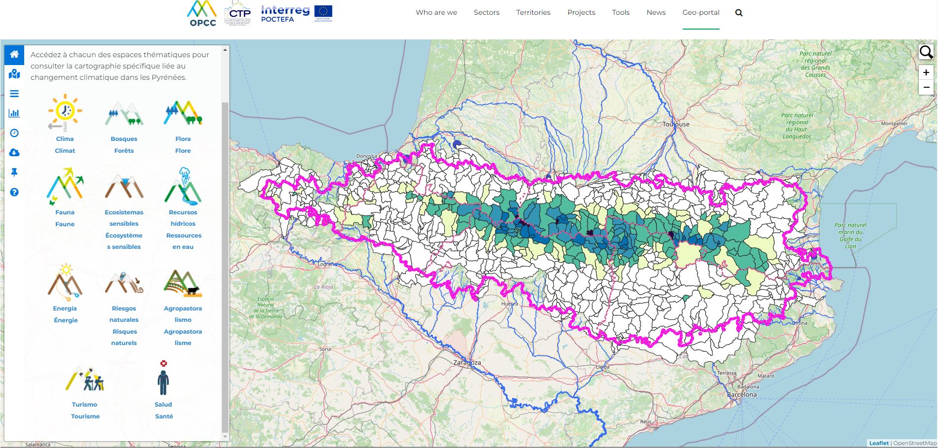
The OPCC geoportal: a key GIS web tool for the capitalisation of climate indicators
The rise of European projects on climate change and adaptation is a sign of the growing concern about the issue at European and Pyrenean level. However, most of these projects are of short duration and the results are often obtained during the final stages of project implementation and closure. This situation often limits the dissemination and transfer of results which, despite their great value for climate action, are not sufficiently publicised. This tool makes it possible to perpetuate the results and guarantee their use by other interested persons and entities (scientific community, public policy managers, agents of the productive sectors, educational community and society in general).
On the other hand, the results and key information of the projects are often scattered and distributed among different websites of different projects and entities, so it is not always easy to find the information. In addition, most project websites become obsolete and unusable once the projects have ended, making it difficult to maintain and update the different results and information of interest.
Aware of this problem, the OPCC launched its geoportal in 2017. An open source web GIS tool whose purpose is to capitalise on the key results on climate change in the Pyrenees in a single application. In this news item dedicated to the geoportal, we would like to highlight 2 of the latest updates.
Geoportal and water resources: capitalisation of POCTEFA OPCC ADAPYR and PIRAGUA projects
Thanks to the POCTEFA OPCC ADAPYR project, more than 350 new layers of cartographic information on indicators of the impact of climate change on glaciers, forests, flora, lakes and peat bogs have been made permanent, as well as updating and making available to users the homogenised and updated climate database for the entire cross-border Pyrenean territory.
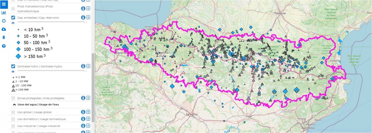
Map of reservoir capacity and installed capacity of power stations in the Pyrenees.
We would also like to highlight the large amount of new information relating to the water resources of the cross-border Pyrenean territory, both in terms of water use and hydrology and water balance. The indicators generated were obtained thanks to the valorisation of the results of the INTERREG POCTEFA PIRAGUA project.
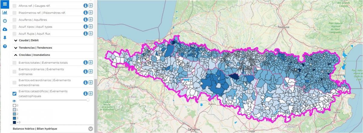
Map of flood disasters in the Pyrenees between 1981 and 2015.
Projects such as PIRAGUA feed the OPCC geoportal with key information for adaptation to climate change, which can be consulted and downloaded in cartographic and graphic format. Some of these key indicators are the evolution of average and minimum flows of Pyrenean rivers, the capacity of reservoirs in the Pyrenean transboundary territory or the expected evolution of evapotranspiration, snowpack or aquifer recharge under different climate change scenarios (RCP4.5 and 8.5, for different time horizons and hydrological models).
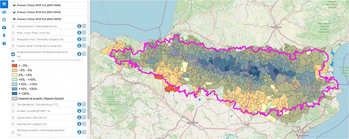
Map of potential evapotranspiration projected for 2041-2070, according to the RCP 8.5 scenario.
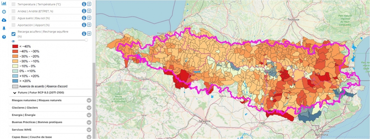
Percentage change in mean annual aquifer recharge for the period 2011-2040 compared with 1981-2010, under the RCP 8.5 scenario: median of the nine GCM/RCM models considered (6 SWAT simulations + 3 SASER simulations). Dashed lines indicate poor agreement between simulations (less than 80% of simulations agree on the sign of the change).
Geoportal and natural risks: capitalisation of the INTERREG SUDOE project MONTCLIMA
The MONTCLIMA project has made it possible to improve the management and prevention of natural risks in the SUDOE mountains, paying particular attention to the multi-risk perspective and climate change. Thanks to MONTCLIMA, it has been possible to capitalise on key information on the risk of floods, fires, droughts and erosion in the mountains of south-west Europe, taking into account the aggravating factor of climate change.
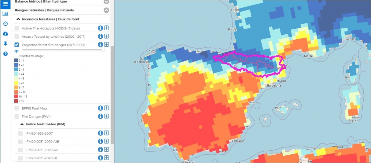
Projected forest fire risk for the period 2071-2100 (seasonal severity index).
In this way, the MONTCLIMA map viewer capitalises indicators and data sets of interest such as flood risk in real time, the susceptibility to erosion of the territory, current and future flood risk and the evolution of the risk of forest fires. It is an online cartographic tool that enables all the information available on the past, present and future (potential) vulnerability of these mountain territories to be valued and aggregated in a single application.
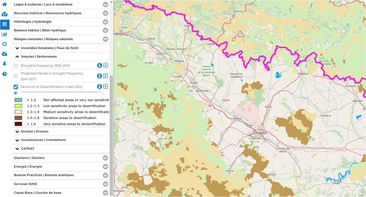
Desertification susceptibility map.
Thanks to this cartographic tool, more than 200 datasets of information on past and future vulnerability to the four risks under study have been evaluated
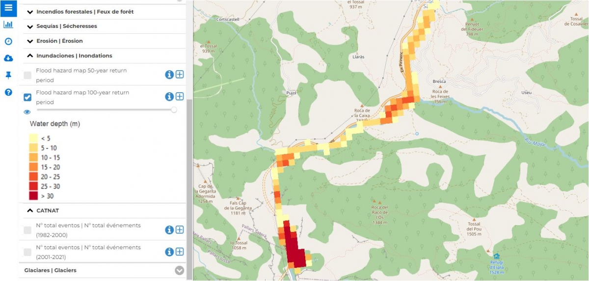
Map of areas at risk of significant potential flooding with a return period of 100 years in Tremp (Catalonia) in metres.
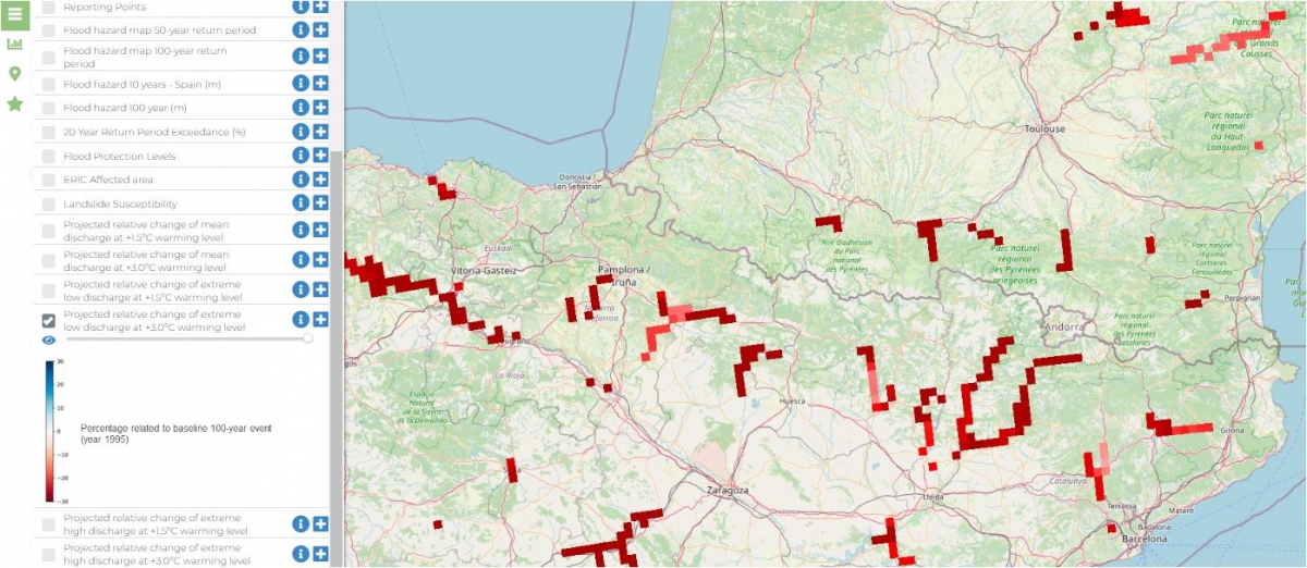
Predicted relative change in extreme minimum flows in the Pyrenees (% change compared with 1995) under a +3.0ºC warming scenario.
All this information is now available on the OPCC geoportal in the natural hazards section of the main thematic menu.
The OPCC geoportal is now more than ever the reference repository of climate data and sectoral indicators of the impact of climate change on forests, water resources, flora and, as a novelty, also fauna, cryosphere and natural risks for the Pyrenees territory.


PYRENEAN CLIMATE CHANGE OBSERVATORY
Avenida Nuestra Señora de la Victoria, 8
22.700 - Jaca
Huesca - España
+34 974 36 31 00
info_opcc@ctp.org